 Longs Peak (14,259 ft), Rocky Mountain National Park, Colorado
Longs Peak (14,259 ft), Rocky Mountain National Park, Colorado
 |
| Hike Stats | Date: Aug 23, 1998 | |
| Longs Peak: 14,259 feet | Base: 9,410 feet | Vertical Rise: 4,849 feet |
| Start: 06:45 | Summit: 17:30 | Return: N/A |
| RT Dist: ~16 miles | Conditions: sunny & clear, snow above treeline | |
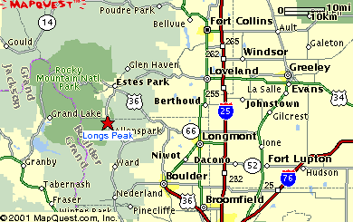
Longs Peak is the tallest point in Rocky Mountain National Park, a magnificent quarter million acres of alpine and sub-alpine wilderness in Northern Colorado. Half of the entire park is above tree line! Ironically, Longs Peak is the only peak within the park over 14,000 feet in elevation, but the surrounding areas are nevertheless impressive. It's like a little Tibet in Colorado.
Much like Pikes Peak, Longs has its share of rich history. It was first spotted by Stephen Long in 1820, and the first recorded climb was made in 1868 by John Wesley Powell, the same dude who was credited with the maiden exploration of the Grand Canyon. The 1963 American expedition party to Mt. Everest used Longs Peak as training for the occasion. Longs Peak has always intrigued climbers more than hikers due to its sheer east cliff crowned by the infamous 1,000-foot Diamond Face. However, our job was just to get to the top anyway we can.
This hike isn't as long as the Barr Trail up Pikes Peak, nor does it have nearly the elevation gain, but I consider it a much more difficult ascent since the majority of the trail is above tree line. There are several ways to get to the top, but the most popular route starts at the Longs Peak Ranger Station near Allenspark, up the tundra and Boulder Field, through the Key Hole, and around the north side of the peak. The elevation at the trailhead is 9,400 feet, and the peak rests at an impressive 14,259 feet -- 16 miles round trip.
My friend Scott (who grew up in Boulder) and I started our journey from his house in Boulder around 5:30 am. That may sound early, but believe it or not most people begin this hike from the trailhead much earlier than that to avoid the almost certain afternoon storms. We began the hike around 6:45 am, something we almost regretted in retrospect. This set of photos chronicle our journey that August day in 1988 and captures some of the spectacular scenery in Rocky Mountain National Park.
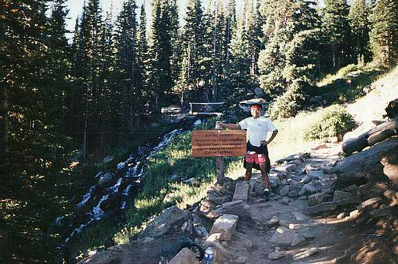
I recall being a bit under the weather the day before, and having taken some pretty strong cold medicine the night before, felt better by the time the hike got underway. Similar to our hike up Pikes Peak, we almost immediately felt the effects of the altitude because we live in Phoenix. In the first hour or so, we were just trying to find our pace. This picture was taken in the first quarter of the hike where the trail still snaked through a dense forest area. The little stream was a picturesque place for us to take a quick break. Elevation is roughly 10,500 feet here.
 |
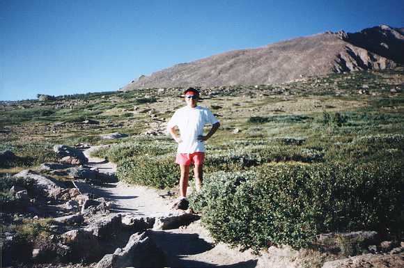
The trail quickly climbs above tree line and dumps us out on a large alpine tundra. Here I am in the tundra grass with a bit of the peak behind me. The part you see is the incline just south of Longs Peak. (Does it look like a beaver's tail?) An interesting bit of trivia: in James Michener's epic novel Centennial, he likened this part of the mountain to a beaver crawling up toward Longs Peak. The elevation where I'm standing is about 12,500 feet.
 |
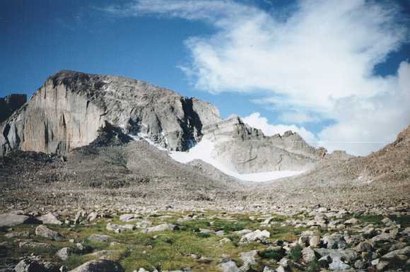
A little bit further along the trail, I captured this photo of Longs Peak. You can see the sharp drop-off on its east cliff and the infamous Diamond Face. The snow run-off covers a low lying area where Chasm Lake can be found. If you look up and to the right from the rightmost tip of the snowy area, you can see a rock formation known as "the Key Hole". The "hill" at the right edge of the photo is Mount Lady Washington.
From here, we begin a long and monotonous trek to the right and around Lady Washington to a point called Granite Pass. Then, the trail doubles back across a long stretch known as "the Boulder Field" and goes up and through the Key Hole. On the back side of the mountain, the trail dips into a Trough and then finally up to the peak. The part from here to the Key Hole is pretty flat (less than 500 feet of elevation gain), but it really wears one down at such high altitude.
 |
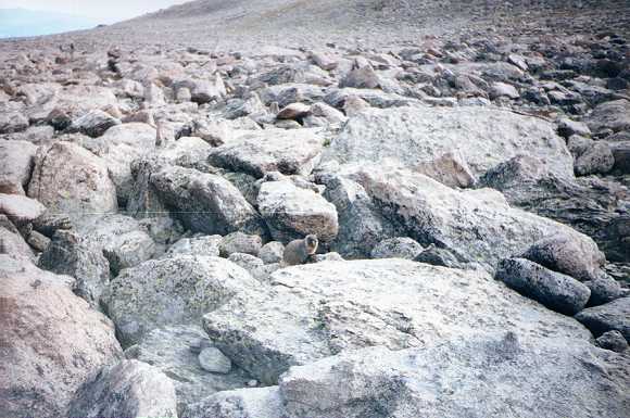
Marmot!!! For those who may be unfamiliar with them, a marmot is a large rodent that's something of a cross between a beaver, a rat, and a squirrel. It only lives above 13,000 feet and survives by foraging for food among the tundra grass. Some say the reason they live at such elevation is because they thrive on the euphoric sensation brought on by oxygen deprivation, but that may be an urban myth. This cute little guy was begging for some peanut-butter cookies we had with us, and proceeded to eat a piece we gave him by grasping it with his front paws.
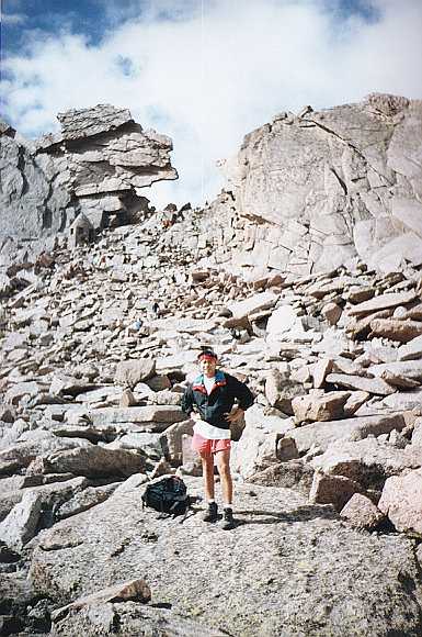
We are now on the other side of Lady Washington. This picture was taken along the stretch below the Key Hole known as the Boulder Field. Can you guess where they got the name? This field ran for about a mile and a half, and really wore me down. I think my illness was starting to catch up with me here, amplified by the high altitude.
 |
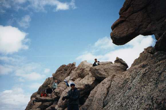
At last, we reached the Key Hole. It was a welcome sight since it marked the end of our long boring flat hike around Lady Washington. However, we knew the back side was tougher. By this time, I was not feeling well at all. The altitude has given me a pretty nice headache, and I was out of breath.
The little hut with the conical dome to the lower left of the Key Hole was built to commemorate Miss Agnes Vaille who died here in 1925 after the first successful winter ascent up the east face of Longs Peak. It's known as the Agnes Vaille Shelter, but is pretty much useless as far as a shelter goes.
 |
The Key Hole (elevation around 13,300) is well known as the transition point into nasty weather, and on this particular day (much to our chagrin), it was no exception. As soon as we stepped across the Key Hole, howling winds of about 30 mph greeted us, and the temperature dropped 20 degrees. Off in the distance we could hear thunder and it started to drizzle a little, threatening to do more.
In this photo, you see Scott (top) as well as many fellow hikers getting out their rain and cold weather gear and gloves. At this point, Scott and I seriously discussed turning back to avoid getting stuck in a storm. We came well prepared, but were very afraid of the conditions getting worse. After much uncertainty and doubt, we decided to continue on a little further and monitor the storm to see if it gets any closer to us. Fortunately, it never did.
 |
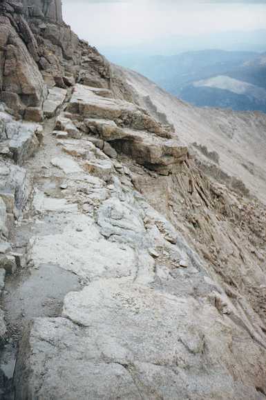
On the back side of the Key Hole, the trail gets pretty treacherous. First comes a section called "the Ledges" where the trail gets quite narrow and offers a certain death if you were to miss a step. Then (the worst part in my opinion), the trail dips about 300 feet in elevation into a large smooth couloir called "the Trough." (A couloir, French for corridor, is essentially a gully on the side of a hill created by years of water run-off.) It was very demoralizing knowing that I must regain the 300 feet of lost elevation!
Climbing out of the Trough takes you to a flat stretch called "the Narrows", shown in this picture. It's another section of extremely narrow passage, but offers some amazing views off to the side. Just don't look and walk at the same time! I wouldn't trust my balance at this altitude. At this point, I was not faring well at all. The altitude and my illness from the previous day had taken their toll. Scott went on ahead, and I slowly plodded along step by step. The elevation at this point is about 14,000 feet.
 |
At the end of the Narrows, the trail turns upward in a narrow couloir called "the Homestretch". This last 200 vertical feet or so is not the cake-walk its name suggests! The path is rocky and steeper than the Trough, and the only thing driving me onward now is my mental determination. All my physical strength and capabilities have left me. Luckily there was no snow; otherwise it would have been really nasty.
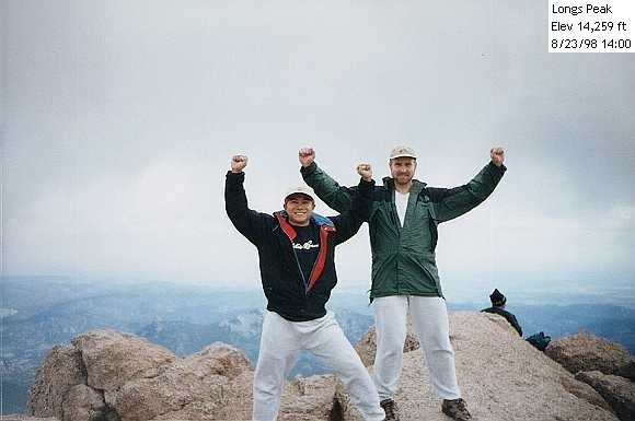
Success at last! I reached the top about 30-minutes after Scott; it's now around 2 pm. We were both exhausted but were understandably elated to do the obligatory victory pose. The weather had improved slightly, but you can see from the clouds behind us that it is still threatening. The temperature was about 30 degrees, and we were both bundled in sweats and jackets.
 |
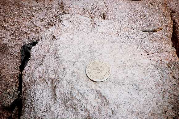
This is a picture of the US Geological Survey marker atop Longs Peak. 14,255 feet it declares (actually, it's now surveyed at 14,259 feet), and we were impressed -- our second fourteener conquered!
The top of Longs Peak is large and flat, unlike Pikes Peak. There must be about 5 acres of flat area up here. We took a rest and walked around briefly, but started the descent quickly in order to avoid any bad weather. Man, I wish we had a cog railroad to take us back to the bottom! We were in no mood to retrace our steps.
 |
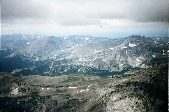
From the top of Longs Peak, this is a picture looking west into the heart of Rocky Mountain National Park and across the Continental Divide. Simply spectacular and literally breath-taking!
Our descent from the peak was uneventful, long, and excruciatingly boring. We returned to the Ranger Station around 5:30 pm. By the time we reached the bottom, I had recovered a bit but Scott started to feel worse. All in a day's work! Despite the difficulties on this hike though, we were both very glad that we came to experience the majestic Longs Peak, and even happier to have reached the summit on our first attempt!
 |
| Prev | Next | Index |